Backup Only

This Week's Walks - Archive

Please see the Saturday Walker's Club This Week's Walks page.

This is an archive of walks done by the Saturday Walker's Club. You should only need to use this page if the SWC website is down.

Thursday, 22 August 2024

Evening Walk - Wimbledon Common and Putney Vale [New Evening Walk]

Length: 10.0 km 
Ascent/Descent: 80m 
Net Walking Time: 2 hours
 
Take the 18.09 service from Waterloo (calls Vauxhall, Clapham J), arrives Wimbledon 18.25. W’don is also served by the District Line. 
Fast Return trains are frequent.
 

An A road (can be avoided by a slightly longer route along residential streets) at start and finish and in-between: Wimbledon Common and Putney Vale.

Refreshments: Plenty of options in Wimbledon.

For a detailed route map, gpx/kml file, photos and pdf directions click here. T=swc.206

Wednesday, 21 August 2024

A seaside walk: Faversham to Whitstable

Length:15.7 km (9.8 miles) 1/10

This walk was done in a storm last year so I'm hoping for better luck this time - it's an easy walk along the coast from Faversham to Whitstable (although you may be tempted to linger in Faversham which has attractive cafes). High tide is from around 1-3 pm so a swim might be possible somewhere between Seasalter and Whitstable; the sea will certainly be warm enough. Apologies to anyone already going to Faversham on Sunday 18, but there isn't much overlap with that walk.

Trains: 1010 from Victoria (Bromley 1026) arrives Faversham 1125. Two return trains an hour from Whitstable at varying times; the train at 50 past the hour goes to St Pancras and you change at Faversham for Victoria. Get a return to Whitstable; if you're planning to return by St Pancras you'll need a ticket that's valid on HS1.

Lunch: Forget-me-not Cafe and Tearoom 400 Faversham Road, Seasalter, CT5 4BW located 9.7km from the start of the walk, was tried out last year. It's not large but has decent lunch options. Otherwise picnic on the beach nearby.

Tea: numerous places in Whitstable including the prominent Neptune pub on the beach front. If that's too busy, the Ship Centurion on the High Street might make a good alternative. The Tudor Tea Rooms 29 Harbour Street, CT5 1AH (tel. 01277 273167) is suggested in the notes.

For walk directions, map and GPX click here

T=swc.12

Sunday, 18 August 2024

Sunday Walk: Winchelsea to Hastings

20.3km (12.6 miles) 9/10
Starts off flat but it doesn't stay that way. No sirree.. After an early lunch at a 17th century pub in Icklesham, the afternoon goes up, down, up, down, through 3 steep seaside glens, eventually descending into Hastings old town. Said to be one of our hardest walks, but Mr Tiger's done it a few times without complaining. So don't expect no medals or nothing.
An unofficial diversion (at your own risk) would take you down to the naturist beach at Fairlight Glen.
T=1.25
Trains Take the 9:40 Highspeed from St Pancras to Ashford International arriving 10:18.
Change to Platform 1 for the 10:24  arriving Winchelsea 10:53
Return from Hastings at xx:25 for St Pancras (via Ashford) or the xx:00 and 30 to London Bridge or xx:19 to Victoria (longest journey).
Get a return to Hastings.
Lunch: Queens Head (tel 01424 814 552), Parsonage Lane, Icklesham.
Or later in the village of Pett, the Royal Oak Inn (tel 01424 812 515)
There is the  C-Side cafe on the sea wall in Pett Level and a restaurant, Cockles and Dreams, a little further on.
Tea: At least two good pubs in the old town, as well as cafes and fish and chip places.
Directions: here.

Sunday Walk: Faversham Circular

Main Walk: 19½ km (12.1 miles).
Short Walk, omitting Oare Marshes: 14½ km (9.0 miles). Difficulty 2 out of 10.
The walk starts with a loop around Ham Marshes, an isolated area between two creeks. After a lunch stop in either Hollowshore or Oare, the walk continues  through Oare Gunpowder Works Country Park, where remains of that industry can be seen amongst woodland and wetland. Its Visitor Centre (open 10–4) tells its story and details the local wildlife.
Then, a quiet country lane leads you to the hamlet of Luddenham, and its impressive medieval church. Here, you have a choice of endings, short or long. The longer one takes you round Oare Marshes Nature Reserve. Both endings go back through Oare and Faversham.
There are plenty of opportunities for bird-watching so bring your bins.
Faversham is an attractive market town with many historic buildings. Print out this history trail to find a few.
Lunch    
The first pub encountered is the remote Shipwright's Arms (01795-590088) in Hollowshore. This old-fashioned pub does not take bookings and caters mainly to birders and walkers on the coast path, with a limited menu: burgers, jacket potatoes, sandwiches, etc. From what I remember, it has an encouraging range of beer and cider.
Twenty minutes further, there are two pubs and a café in the village of Oare. The Castle  (01795-533674) is a traditional pub where it would be advisable to book. Ditto for the more upmarket Three Mariners  (01795-533633). Lighter fare is available at The Cafe by the Creek (01795-537985)
Tea 
There are many possible refreshment places in Faversham. Three near the central Market Place are The Refinery at 122 West Street (a coffee shop and bar, open to 4) and, on Court Street, Café Guild at #48 (01795-590077; open to 5) and Havishams Caffè at #47 (01795-591571 open to 4). Nearby is Faversham's oldest surviving pub, the Bear with its quaint old corridor.
Other pubs include a Wetherspoon's, the Leading Light (01795-535075) and, near the station, the Railway Hotel (01795-501550).
Trains
I'm suggesting the cheaper, slower option from Victoria, the 10:05 arriving at 11:18
You could get the 10:20 from St Pancras (10:27 Stratford Int.) arrives Faversham 11:26. Faster but costs more. You’ll have to walk faster or take the shorter marsh route if they haven’t waited for you. 

Trains return at xx:00 to St Pancras and xx:37 and 44 to Victoria. You need a Highspeed ticket or supplement for St Pancras.

Directions here
T=swc.420


Saturday, 17 August 2024

Dorking Circular

Dorking Circular via Wotton (and Friday Street)

Length: Main Walk, via Wotton and Friday Street: 18.5 km (11.5 miles). Short Walk, omitting Friday Street : 16km (9.9 miles).

Difficulty: 6 out of 10 for the main walk, 4 out of 10 for the short walk.

There are no trains to Dorking Main today due to engineering works so take the 10.00 from London Bridge to Redhill (10.35) where you have 5 minutes to hop over to platform 1b for the 10.40 train to Dorking Deepdene, arriving 10.52. If you want more time to change trains at Redhill, you could take the 09:51 from London Bridge arriving at Redhill at 10:22

Trains back from Dorking Deepdene are at xx:00, xx:25. There's also a train from Dorking West every 2 hours 1454, 1654 etc... (also changing at Redill)

Buy a return to Dorking Stations.

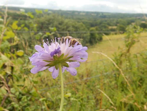
Wild Flower. Bee on Scabious "The walk starts with a long stretch along the lower chalk slopes of the National Trust's Denbies Hillside, a Site of Special Scientific Interest (SSSI). The Main Walk then heads south into the wooded Greensand Hills, going through the extensive Wotton Estate to the picturesque hamlet of Friday Street with its large Hammer Pond. The return leg crosses a number of ridges on open access land managed by the Surrey Wildlife Trust and the Forestry Commission. After passing the large ponds of Bury Hill Fisheries a final climb takes you along the top of The Nower, a semi-natural woodland reserve with splendid views". There should be some pretty wildflowers.

The suggested lunch pub on the Main and Short Walks is The Wotton Hatch (01306-887694) after 7½ km. Anyone having a picnic could stop about 5 mins before the pub in the churchyard of St John the Evangelist.

Back in Dorking, there are several cafes and pubs. Last time, we went to Harts At The Courtyard (01306 743528), which has outside seating in a courtyard setting away from the main road. It's at 3, Old Kings Head Court, 11 High St, Dorking RH4 1AR

Please remember that these walks don't have a leader so come prepared with the SWC directions, gps route and/or map from L=swc.274 page.

Sandling to Folkestone - a swimming walk

Length: 11.2 km (7 miles) or 13.4km (8.3 miles) T=swc.51

Catch the 9.34 train from Charing Cross (9.37 Waterloo East, 9.43 London Bridge) to Sandling, arriving 11.14

OR

Catch the 10.04 Southeastern High Speed train from St Pancras International to Ashford International, changing there to the above train, (arrive 10.42, depart 11.02). Note that the high speed train gives an even bigger time advantage on the way back: see Trains back below

Buy a day return to Folkestone (with high speed supplement if relevant)

For walk directions click here, for GPX click here, for a map of the route click here

This walk was unashamedly created as a summer swimming walk. The idea is to give you a decent length morning, with some nice upping and downing in fine scenery, a castle or vineyard or two, etc etc, and then bring you down to pretty Sandgate for lunch (cafes, pubs, tea kiosk: all sorts).  The short afternoon then provides pleasant sea swimming opportunities.

You can swim at Sandgate, whose seafront has a rather Mediterranean air in the sunshine, but there can be quite strong lateral currents here: that is to say the current is going one way or other parallel to the shore, and you find yourself making too much progress one way and none at all the other.

A better choice, which also allows your lunch to settle, is to walk the mere mile or so along the promenade to the Mermaid Beach of Folkestone, whose scalloped shape provides calm waters and very pleasant swimming in nice scenery. High tide is at 9.49 today and low tide at 5pm, so by the time you get there it will be getting towards the lower end, when there is plenty of shallow water and a sandy bottom near the shore, with plenty enough water depth further out for those that want to be a bit bolder.

There is a cafe overlooking the Mermaid Beach, and also a new tea kiosk in the Leas Park, near the foot of the Zigzag Path.

To finish your walk, you can stroll along the seafront to the Harbour Arm, the now revamped former cross-channel port of Folkestone, where there all sorts of food kiosks and places to have drinks. There is also an Antony Gormley statue hidden away somewhere, and in general Folkestone has lots of art installations if you want to explore them. Or for a shorter way to the station, climb the charming Zigzag Path.

Trains back are at 05 past to Charing Cross (1 hr 46m or 1hr 38 to London Bridge) or 58 past to St Pancras (56 minutes)




Uckfield to Pease Pottage

Map walk - Uckfield to Pease Pottage 
Length: 36.5 km (22.7 miles). Toughness: 3/10 
Option to end at Horsted Keynes after 15.5km 

Catch the 9:07 from London Bridge arrives Uckfield 10:22. 
Buy a single to Uckfield. 
(If quitting at Horsted Keynes and catching the bus back to East Grinstead rather than Haywards Heath a return to Uckfield might be best.) 

Return from Pease Pottage, by the fairly frequent bus 20 (24 hour service) to Gatwick or Horley stations for trains through the night to London.

Ending at Horsted Keynes: 
Bus 270 from Horsted Keynes to Haywards Heath 15:39 16:39 17:57 19:34
Bus 270 from Horsted Keynes to East Grinstead 15:43 16:44 17:43 18:40 19:29 20:37

This is a map based walk - it is preferable to have the gpx on your smartphone / gpx device. 

This is the 2nd stage (of 5) of a walk from Robertsbridge to South Harting, inspired by Hilaire Belloc's walk undertaken in 1902, and detailed in his book The Four Men: A Farrago. Sections of the route taken in 1902 were along "cart tracks" which are now roads. Consequently the route taken varies from the 1902 route, but passes by sights and villages and pubs detailed in the book.

This second section is from Uckfield to Pease Pottage, although there is a convenient drop out point at Horsted Keynes.

Belloc took four days to complete the walk from Robertsbridge to South Harting, so we are already behind. Friday 31st October 1902: Set off early for Ardingly and then onto Tilgate to stop at the Swan Inn*, Pease Pottage for some ale. Then onto St. Leonards Forest and Shelley Plain, Leonards Lee, Crabtree Inn, Crabtree to arrive just after 3pm at Little Cowfold. South towards Henfield to stop at an inn for a meal. After which took the Ashurst Road to spend the night in a barn. (Sent out to the Fountain Inn, Ashurst for bread, cheese and Steyning ale.)

*Now the Black Swan Inn


  T=swc.432

Thursday, 15 August 2024

Evening Walk - Waterlink Way (Lower Sydenham to Catford, Ladywell, Lewisham or Greenwich)

Length: up to 9.7 km (6.0 mi) [several dropout points en route] 
Ascent/Descent: negligible
Net Walking Time: up to ca. 2 ¼ hours 

Take the 18.10 Hayes (Kent) train from Charing X (18.13 W’loo East, 18.19 London Bridge, 18.29 Ladywell, 18.31 Catford Bridge), arrives Lower Sydenham at 18.34. 
From locations further south, take the 18.14 train from Hayes to Charing X, arrives Lower Sydenham at 18.30 
 
Finish is at one of: Ladywell Rail, either of the Catford Stations, Lewisham Rail/DLR, Cutty Sark DLR or Greenwich Rail/DLR. 
Return trains from these stations go to either London Bridge, then Cannon Street or Charing Cross, or to Blackfriars via Peckham Rye and Elephant.
 
The route connects a number of attractive parks and green spaces in South East London, while following the Pool and Ravensbourne Rivers. It follows parts of the well-waymarked Waterlink Way, the London-part of the National Cycle Network Route connecting Eastbourne to the Thames. Large stretches of those rivers have in recent years been re-naturalised or at least sympathetically embedded in landscaped linear parks such as Ladywell Fields and Brookmill Park, and as such the route makes for a pleasant outing in a densely populated part of London, even though some formerly highly industrialised areas such as Deptford as well as some densely built-up areas such as Catford and Lewisham are passed through.

Walk Options: The walk route runs past a few Railway and DLR stations (Catford/Catford Bridge, Ladywell, Lewisham, Elverson Road and Deptford Bridge), enabling an earlier finish or later start.

Refreshments en route: the Catford Bridge Tavern in Catford, The Ladywell Tavern in Ladywell, The Brookmill in St. John’s and The Birds Nest in Deptford. Plus, plenty options in Greenwich.

For summary, walk directions, map, height profile, photos and gpx/kml files click here. T=short.36

Wednesday, 14 August 2024

Milford to Haslemere

 Length: 18.3 km (11.4 miles) 6/10

While the days are still fairly long, a walk over remote heathland and past some pretty lakes in the morning, and the Devil's Punchbowl in the afternoon. Shady woodland and heather on the commons. The main walk route goes down into the Devil's Punchbowl (700m longer with at least 100m extra ascent), but my preference is for the alternative scenic route round the rim of the punchbowl to the NT cafe.

Trains: 0945 from Waterloo (Clapham Junction 0952, Woking 1012) arriving at 1038. Four return trains an hour back from Haslemere. Get a return to Haslemere.

Lunch: The community owned Three Horseshoes "pub with good food" in Thursley (tel. 01252 703900) is 7.9 km into the walk. The churchyard some 500m further on makes a good picnic spot.

Tea: The National Trust’s Devil’s Punch Bowl Café (tel. 01428 606565) could be an early tea stop and is open until 5pm. In Haslemere there is Hemingways (tel 01428 643 048) or Darnleys (tel 01428 643 048) on the High Street, and several nearby pubs.

Walk options: you could follow the main route into the punchbowl instead of walking along the rim. As mentioned this is about 700m longer. After the NT cafe, you could detour up Gibbet Hill instead of following the Greensand Way towards Haslemere (adds 1.2 km; less if you combined these two options without visiting the cafe).

For walk directions, map and GPX click here

T=1.27