Backup Only

This Week's Walks - Archive

Please see the Saturday Walker's Club This Week's Walks page.

This is an archive of walks done by the Saturday Walker's Club. You should only need to use this page if the SWC website is down.

Sunday, 18 May 2025

Sunday Walk - Pewsey Circular: North Wessex Downs, a Chalk Figure, some stunning views across the Vale of Pewsey

Length: 27.0 km (16.8 mi) [shorter walk possible, see below]
Ascent/Descent: 380m
Net Walking Time: ca. 6 hours
Toughness: 6 out of 10
 
Take the 10.30 Paignton train from Paddington (11.01 Reading, 11.16 Newbury , 11.25 Hungerford), arriving Pewsey at 11.37 
Return trains : 16.58 (73 mins), 19.01 (70 mins) or 22.14 (79 mins).

Split Tickets and Network Railcards: All return trains stop in Newbury and Reading and all but the last one also in Hungerford, so a split ticket London – Hungerford and Hungerford- Pewsey will give you the best prices (unless you are planning to take the last train back, in which case split the ticket at Newbury). The Network Railcard is valid to Hungerford, so split the ticket there AND take a return train no later than the 19.01.

Exhilarating excursion through the solitude of the Vale of Pewsey, which separates the chalk upland of the North Wessex Downs to the north from that of Salisbury Plain to the south, including an ascent up the southerly hill chain of the Marlborough Downs, from where there are stunning far views in all directions over this land of wave-like hills, with its scarps, ridges and valleys. It is a mysterious landscape, full of pre-historic earthworks and hillforts as well as barrows – burial mounds of kings and warriors. After a scenic descent back into the Vale of Pewsey, your tea options are in the hamlet of Honeystreet. Finally, an undemanding stretch along the Kennet & Avon Canal leads back to Pewsey.

Two Shortcuts on the Downs are possible , they reduce the walk by 3.5 km (2.1 mi) or 3.4 km (2.1 mi) respectively. See route map and pdf for details.

 
Lunch: Picnic
Tea: Honeystreet Mill Café in Honeystreet (19.6 km/12.2 mi, open to 17.00), or The Barge Inn (20.0 km, open all day), also in Honeystreet, plus one other en route and several others in Pewsey; check the walk directions pdf.
 
For summary, walk directions, map, height profile, photos and gpx/kml files click here. T=swc.127

Saturday, 17 May 2025

Saturday Walk - Henley Circular via Great Wood Walk

Temple Island, Hambleden & the Great Wood

Length: 16.1 km (10 miles)

Toughness: 3 out of 10

This is a very pretty walk, out along the sparkling waters of the river Thames, and back via the hills above. You follow the Thames path in the morning to attractive hamlet of Hambleden with its brick and flint red roofed buildings. The return is via the wooded geological terrace above river.

After lunch, the walk for the next 2.5km takes you through the Great Wood, the endlessness of which gives an inkling of how most of Britain must once have been. From the village of Fawley with its church and mausoleum, the walk returns along the Oxfordshire Way, past the manor of Henley Park, to Henley for tea.

Travel:  Take the 10.08 train from Paddington to Twyford (arrives 10.37) change to the 10.45 train from Twyford, arriving Henley on thames 10.57.

Return trains: xx.00 and xx.30 mins past the hour.

Ticket: Return to Henley on thames

Lunch: Lunch: The Stag & Huntsman (01491 571 227), in Hambleden. For picnics, the nearby church.  There is also a little shop with benches outside, which does sandwiches, cakes etc.

Tea:  Plenty of options in Henley, including The Chocolate Café in Henley (now renamed as Viv’s) and the Weatherspoons or The Angel on the Bridge pub to name but a few.

T=1.1

Extension:  If you would like to extend this walk (by about 2 miles), then continue along the Thames towpath towards Shiplake passing a pretty lock and weir and a watermeadow.  You then vier off the path towards Shiplake station through the suburb.  Trains back to xx.o4 and 00.34.  Pub near the station is the Baskerville Arms. Your Henley ticket will cover you for the return to London from Shiplake.


Saturday Walk - Balcombe Circular via Nymans (National Trust)

Length: 19km (11.8 miles), 5 hours walking, 5 out of 10
"This walk is full of small delights: a nature reserve and lake with Japanese pavilion down by the stream below the impressive gardens and park of Nymans (National Trust) with its part-ruined manor house; a churchyard in Slaugham (pronounced 'Slaffam') with a 600-year-old yew tree some 10 metres in circumference; the ruins of Slaugham Manor; then a walk down to the River Ouse."
You should use the online directions in order to get the route to a tunnel under the A23 (motorway)

Trains: Get the 1005 Thameslink Brighton train from London Bridge (East Croydon 1019) arriving 1046. Return trains are xx25 xx55.

Lunch: Early in Handcross at the Red Lion, after 3.5 miles, 5.6km. After 7.6km there is the Heritage in Slaugham, an altogether more upmarket place.
After 7.5 miles, 12km (3 hours) you get to Staplefield and The Victory Inn (tel 01444 400 463) all day at weekends for a late lunch or early tea. On the other side of Staplefield Green, some 300 metres north of the Victory Inn, The Jolly Tanners (tel 01444 400 335), a family run village pub with a pleasant beer garden. This gives you only 3 miles left to get to the station.

Tea: The Half Moon, an excellent community pub.
T=1.16

Saturday Walk - Pulborough to Halfway Bridge or Petworth via Tillington

Length: 26.0 km (16.1 mi) [shorter or longer walk possible] 
Ascent/Descent: 484/467m  
Net Walking Time: ca. 6 hours 
Toughness: 7 out of 10
 
Take the 09.05 Portsmouth Harbour & Bognor Regis train from Victoria, arriving Pulborough at 10.22 (you have to be in the rear part of the train, as it splits in Horsham) [CJ 09.12, EC 09.23]. 
After the walk you will need to catch a Bus Line 1 (Midhurst – Worthing via Pulborough Station) from Halfway Bridge. The bus leaves Midhurst hourly on xx.30, then 15.35, 16.40, 17.50 and 19.00 and passes Halfway Bridge six minutes later, Tillington 11 and Petworth 14 later resp. 
Return trains: xx.24 and xx.54.

This walk is a winding excursion through the Rother and Lod valleys in central West Sussex, routing through various quaint, remote villages, some atmospheric woods and several fine commons, part-wooded, part sandy heathland. Frequent southerly views of the South Downs and of Black Down to the north and long stretches in deep, shady holloways add to the mix, making this a very varied outing.

After leaving Pulborough on a westerly route familiar from other walks, past the picturesque Stopham Bridge and church and on to Littleworth Common, the walk leads in a southerly direction through the Rother valley and picks up the Serpent Trail Long Distance Path up to the idyllic Sutton Common heathland and various woods to Burton Park, a large estate with multiple ponds in a fold of the South Downs.

Leaving the Serpent Trail, the two recommended lunch options are back in the Rother valley, in Coultershaw Bridge and Tillington, and in the afternoon the route rises to Upperton and Hoe Hill, in between dropping into the Lod Valley through woods and fields. The finish is a descent back to the Lod River at Halfway Bridge, where another well-run pub helps whiling away the wait for the bus back to Pulborough.

Note: The route off Hoe Hill includes a precipitous descent down a very narrow and slippery gully.

Walk Options 
A Morning Shortcut cuts out Sutton Common heathland (cuts 1.2 km and 48m ascent).
An Afternoon Shortcut cuts out several woods and the last sharp ascents around Hoe Hill by taking a much more direct route through the Lod valley (cuts 4.4 km and 135m ascent). 
Bus Line 1 (see above) can be used for finishing the walk at Tillington (late lunch stop) and Petworth (reached shortly after lunch via an alternative route through Petworth Park). 
For an epic walk, use the alternative route after lunch through Petworth Park to Petworth and there pick up SWC 128’s Pulborough Ending.

Lunch 
The Badgers in Coultershaw Bridge (13.0 km/8.1 mi, food to 14.30); The Horse Guards Inn in Tillington (16.0 km/10.0 mi, food to 15.00).
 
Tea 
The Hollist Arms in Lodsworth (1.6 km from the end); The Halfway Bridge (a table has been booked for 18.00 hours); The Chequers Hotel in Pulborough (650m beyond the station.  
Tea in Petworth 
Audit Room Café at Petworth House (NT); Plenty of options in Petworth.
 
For walk directions, map, height profile , photos and gpx/kml files click here. T=swc.294

Thursday, 15 May 2025

Evening Walk: A Wandle Wander through Beddington Farmlands, Beddington Park, Carshalton Ponds and Village

Extra Walk 273 Mitcham Junction to Carshalton

Length: ~5.75 km (3.5 miles). Toughness 1/10.

18:06 Thameslink Sutton service from London Blackfriars, arriving Mitcham Junction at 18:37 or you could arrive a few minutes earlier on one of the trains below:

18:11 Southern Dorking service from London Victoria (Clapham Junction 18:18, Balham 18:23), arriving Mitcham Junction at 18:33

17:52 Southern Sutton service from London Bridge, arriving Mitcham Junction at 18:27

You can also arrive by tram (frequent services from Wimbledon or East Croydon), but be aware that tram and train journeys are charged separately.

Return trains from Carshalton are at xx:45 and xx:15 to London Victoria, xx:49 and xx:19 to Blackfriars until 21:19 then at xx:51 and xx:21. All stations are in London travelcard zones 1-6 so you can use Oyster or Contactless.

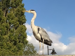
Heron by Carshalton Ponds

This is a short section of the Mitcham Junction to Colliers Wood walk. It starts at Mitcham Junction and follows the published route through part of Mitcham Common and across Beddington Farmlands - a large area being transformed into a new wetlands nature reserve. The route leads you through the attractive Beddington Park with its historic buildings then on to Carshalton Ponds and Carshalton Village, which offers a choice of post walk refreshment places. The Hope (020 8240 1255) 48 West Street SM5 2PR, a community run pub, has been popular in the past. It serves home cooked one-pot meals (until 10pm) and real ales.

You'll need to print the directions from the L=swc.273 page.

Wednesday, 14 May 2025

Wednesday Walk - Lewes to Glynde via Southease (or circular)

T=swc.47
This is the anti-clockwise version of the Lewes circular walk with options to shorten by finishing in Glynde or Southease or carry on from Glynde to Lewes for a longer walk.

Length: Lewes to Southease 11.1 km (6.9 miles), Southease to Glynde 6.3km (3.9 mi!es)
Glynde to Lewes: 6.2km (3.8 miles).

Difficulty: 5 or 6 out of 10 (7 for the complete circuit).

Trains: 9.54 from London Victoria (10.01 Clapham Junction, 10.15 East Croydon) arriving in Lewes 10.56.
Return trains from Lewes xx.25 and xx55.
From Glynde trains run hourly at xx.14. 
Trains from Southease are also hourly at xx.05.
Buy a return ticket to Lewes and a single from Southease or Glynde to Lewes depending on where you decide to finish..

Lunch:  The Abergavenny Arms, Rodmell, 01273 472416, is a popular pub with a pleasant outdoor terrace and is now the only possible lunch pub on this walk. It is open 12pm to 10pm daily and serves food all afternoon until 8.30pm (8pm Sunday). 
The Courtyard cafe at the YHA in Southease is an option for hot drinks and snacks. 

Tea: 
Lots of options in Lewes if you finish the walk there or if changing trains there, The Runaway cafe situated at platform level in Lewes station is an option. They have hot drinks, cakes and some savoury snacks.

L=swc.47 (look for the anti-clockwise directions)

Sunday, 11 May 2025

Sunday Walk – Wateringbury Circular

Extra Walk 336 – Wateringbury Circular

Length: 14 km (8.7 miles), or 16¾ km (10.4 miles) if you finish at Yalding. Toughness: 3/10

09:34 Ramsgate train from Charing Cross (Waterloo East 09:37, London Bridge 09:43, Sevenoaks 10:08), changing at Paddock Wood (arr 10:23, dep 10:33) for the Strood train which arrives Wateringbury at 10:44. Buy a return to Wateringbury.

Trains back are hourly, at xx:09 from Wateringbury and xx:12 from Yalding, again changing at Paddock Wood. In theory you could get a train in the other direction at xx:41/44 and change at Strood for the High Speed Train to St Pancras, but the fare on this route is much more expensive.

Buttercups There are plenty of orchards along the Medway Valley and this should be a good time for apple blossom. There might still be patches of bluebells and wild garlic to be seen, but the predominant colour in the fields will be a bright yellow from swathes of buttercups.

The walk document lists a lot of options but to simplify matters I suggest sticking to the Main Walk. I was going to specify the extra loop out to the Horseshoes Inn on Dean Street, but there was a positive review of the Bull Inn at East Farleigh by the pair who braved a dire weather forecast last time out so it would be nice to give them another try. You should reach this pub at around 12.15–12:30pm, and there's a churchyard across the road for picnickers.

At the end of the afternoon leg tea'n'cake should be available at the Ramblers Rest Café, just across the river from Wateringbury station. If that revives you there's a optional riverside extension to the next station on the line, Yalding. That will take around 40 minutes; it's worth timing your departure carefully since there'll be nothing to entertain you if you have a long wait for the hourly train.

You'll need to bring the directions from the L=swc.336 page. If you're printing them off from the web page (ie. not the pdf download) you can save several sheets of paper by clicking the Main Walk option line first. If you're relying on your GPS device a short study of the route beforehand might help you avoid heading down some of the other walk options.